Salt Lake City sits in a geographic sweet spot that few other metropolitan areas in the United States can match. The towering Wasatch Range rises directly from the eastern edge of the valley, while the Great Salt Lake and the Oquirrh Mountains define the western horizon. This unique topography means you do not need to drive for hours to find solitude, alpine lakes, or challenging switchbacks; you simply need to point your car toward the mountains and go.
The variety of terrain accessible within a thirty-minute drive is staggering. You can hike through shaded aspen groves, scramble across granite ridgelines, or stroll along tranquil creeks without ever leaving the greater Salt Lake area. Because the trails range from paved, accessible paths to strenuous summit climbs, the region serves everyone from families with young children to experienced peak baggers.
Understanding the local climate is essential for a safe and enjoyable outing. The high desert environment means mornings can be crisp even in July, while afternoon thunderstorms are common in late summer. Snow often lingers in the high country well into June, and many canyons have strict watershed regulations that prohibit dogs and swimming.
The hiking culture here is deeply tied to conservation and responsible recreation. The Central Wasatch Commission and local trail organizations work tirelessly to maintain sustainable access, but they rely on visitors to practice Leave No Trace principles. Staying on designated trails, packing out all waste, and respecting seasonal closures helps protect the fragile watershed that supplies the valley’s drinking water.
Access to the Cottonwood Canyons is a major advantage, but it also requires planning. Parking lots at popular trailheads like Millcreek, Big Cottonwood, and Little Cottonwood often fill before sunrise on weekends. Using public transit, carpooling, or hiking on weekdays can dramatically improve your experience.
Whether you are looking for a quick after-work leg stretcher or a full-day alpine adventure, the trails near Salt Lake City deliver world-class scenery. The following list represents the best options for different fitness levels, seasonal windows, and scenic preferences.
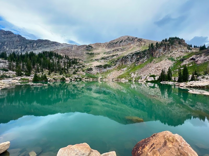
Cecret Lake Trail

| Address | Alta, UT 84092 |
|---|
| Maps | Click here |
|---|
| Website | Click here |
|---|
| Opening Hours | Monday: Open 24 hours
Tuesday: Open 24 hours
Wednesday: Open 24 hours
Thursday: Open 24 hours
Friday: Open 24 hours
Saturday: Open 24 hours
Sunday: Open 24 hours |
|---|
| Phone | — |
|---|
Jenae Giles★★★★★
It is $12 to park here or $6 with a military ID. It is absolutely BREATHTAKING!! The hike to the lake is not long but is really lovely.
The. Lake is small and you cannot touch the water, I am guessing because it is filled with Tiger Salamanders that you can catch glimpses of. I would 100% recommend this as a short, evening hike or someplace to take a romantic picnic to.
Zulena Saravia★★★★★
Beautiful views, halfway through the trail it gets pretty rocky. It’s summer right now so it can get pretty hot and dry so the ground can get pretty dusty making it easy to slip. I definitely recommend grippy shoes or hiking shoes. I did this hike combined with another hike that took us through a meadow of wild flowers. Mostly inclines for the first half of the trail.
eva chan★★★★★
Beautiful trail. Fairly easy. Just about 500 feet from the campground. You can do a loop and hike to the bottom of devils castle to walk back to the campground
Michelle Evans★★★★★
Pretty hike!!! A little piece of heaven of you will. I highly recommend!!! Its an easy hike and it leads to a beautiful lake in the mountains ⛰️.
Berenice Brizuela★★★★★
Amazing ! I’m in Utah for vacations and this spot is a must! Pretty near the city, great trail, beautiful views.. such a great experience here!
The Living Room Trailhead

| Address | 383 Colorow Rd, Salt Lake City, UT 84108 |
|---|
| Maps | Click here |
|---|
| Website | Click here |
|---|
| Opening Hours | Monday: Open 24 hours
Tuesday: Open 24 hours
Wednesday: Open 24 hours
Thursday: Open 24 hours
Friday: Open 24 hours
Saturday: Open 24 hours
Sunday: Open 24 hours |
|---|
| Phone | — |
|---|
April Chatman-Royce★★★★★
This trail is a steady climb for most of it- it levels off with about 200m remaining. Make sure you sit in all of the rock chairs! It’s shaded for the first part and then if you go before 10am, there’s shade along most of the trail. Warm up those calves!!!
Erika M★★★★★
I love a difficult trail, so this was right up my alley! The first ~2 miles is a challenge between the elevation and the steep uphill climb. Then when things level out you end up climbing through the ridge tops with tricky footing. The views are fantastic pretty much the whole time. Highly recommend!!
Brooke Green★★★★★
Nice hike and great views of the Salt Lake Valley. Not a lot of shade or tree cover, a decently step climb. Close to the University and the hospital. 3 hour on street parking available.
Kristina Kavaliunas Dostaliyeva★★★★★
Fun hike up in the hills of SLC. It is rocky and a continuous climb. We struggled some due to elevation (we live in Tezas, at sea level) but made it. Hiking poles would help on the way down.
K S★★★★☆
A steady 45 minutes of incline hiking with a gorgeous view at the top!
We did the hike shortly after landing in Utah and the altitude definitely got to us. Your calves will feel this one for sure too!!
The top was pretty cool with all of the “living room furniture” made from rocks. The view was really, but unfortunately, our sunset hike was a little bit overcast.
would recommend going on a really clear night for Sunset 🙂
Bear Canyon Suspension Bridge Trailhead

| Address | 12625 Highland Dr, Draper, UT 84020 |
|---|
| Maps | Click here |
|---|
| Website | Click here |
|---|
| Opening Hours | Monday: Open 24 hours
Tuesday: Open 24 hours
Wednesday: Open 24 hours
Thursday: Open 24 hours
Friday: Open 24 hours
Saturday: Open 24 hours
Sunday: Open 24 hours |
|---|
| Phone | — |
|---|
Robert Most★★★★★
Nice loop, perfect for watching the sunset from the bridge. Lots of signage, reminders for people to pick up their dog poop, stay on the trail, yada yada…. The bridge was pretty cool, could hear the water rushing way below. Watch for some large batches of poison oak on the trail sides. We saw a long gopher snake; thank goodness it wasn’t a rattler. Overall a great hike to watch the sun go down across the valley.
Chelsea Neilson★★★★★
Family friendly enough to have my 3 year old nephew walking it most the way. We had 2 kids in hiking backpacks. It wasn't too steep, dogs allowed. There were a lot of visitors. When my nephew finally saw the bridge , he was SO excited. It was a very pretty place for pics. Perfect family hike!!
There is a really cool kids climbing rock by the entrance of the trailhead
S T★★★★☆
If needing easier: When you go up the first set of switchbacks, I reccomend going up the right part of the loop instead of the left. Then just come back down the same way. If you go up the left side of the trail it is longer and steeper. Bridge is very cool. Very minimal shade, definitely do when cool or in the morning. Bathrooms are clean at the bottom. We made it work with a wagon and small stroller but I wouldn't reccomend it if you can use carriers instead. Both ways some parts are rocky and semi steep. Took us about 2 hours going up the left and down the right side of the loop. Would have been shorter if we went up and down just the right.
Debbie Carpenter★★★★★
This hike is perfect. Got to the bridge. It's beautiful. It's a rocky climb so where good shoes. Very popular place. I think it's good for all ages except toddlers.
Melissa Vergara Palmer★★★★★
Pretty easy hike. Not much elevation. I carried my 15 month old, wasn't to bad. If your 8 year old likes to hike they could definitely do it. Younger than that might be alittle challenging but doable.
Bell Canyon Granite Trailhead

| Address | 3450 Little Cottonwood Rd, Sandy, UT 84092 |
|---|
| Maps | Click here |
|---|
| Website | Click here |
|---|
| Opening Hours | Monday: 7:00 AM – 10:00 PM
Tuesday: 7:00 AM – 10:00 PM
Wednesday: 7:00 AM – 10:00 PM
Thursday: 7:00 AM – 10:00 PM
Friday: 7:00 AM – 10:00 PM
Saturday: 7:00 AM – 10:00 PM
Sunday: 7:00 AM – 10:00 PM |
|---|
| Phone | — |
|---|
Nomad Life★★★★★
Initially, we arrived at the Bell Canyon Boulder Trailhead. As we were hiking up, I noticed another Bell Canyon Trail sign and I stated jokingly, "we haven't even made it to the trailhead yet. " This made my husband look up the trail on All Trails and realized that the route we were taking doubled the elevation (over 1,000 feet) we would be hiking if we would have started at the Bell Canyon Granite Trailhead. Needless to say, we turned back around and drove to the other trailhead that was 0.2 miles away. There is an even closer parking lot at yhe Preservation Trailhead. This hike is free to do, but dogs are prohibited due to it being a watershed. They do have signs up with QR codes recommending you download an app in case an emergency happens and it would allow for emergency services to find you. This hike is not ADA accessible due to how rocky the trail is. Be mindful as you hike, otherwise you could twist an ankle. We enjoyed this hike, however there are much better hikes out there, weather conditions permitting. It is worth noting that the trail is not shaded. We were burning up in the heat even though we had sunscreen and a hat on. When you make it to Bell Canyon Reservoir, you can enjoy the lake with the beautiful mountainous backdrop that still has snow on its' peaks. Also, you are able to fish here as long as you do catch and release!
There are vault toilets at the trailhead.
Follow us on TikTok for more trip ideas: @nomad.lifestyle
Michael★★★★★
Beautiful trail! Very scenic and fun to explore, with stunning views of the valley, mountains, and reservoir. The creeks and streams that run through here are tranquil and pleasant, and the woodland is fun to venture through.
Morgan Lewis★★★★★
Wow, i’ve hiked this several times and I absolutely adore it. It will come up on a small lake, there are trails leading into the forest and you’ll see a little streams & a bridge going over a river. Hike up to the waterfall is wonderful. It’s really peaceful and when I’ve gone, it hasn’t been overly crowded.
I’ve seen little kids hiking here, kid friendly. You can see the fish swimming in the water. I like going off the trail and just exploring in the woods. It’s incredible & once you get up the initial first part of the hike there’s a meandering trail that goes along the bench and it’s just gorgeous.
Michelle Kim★★★★★
Pretty fun trail, roughly 20 min to get to lake from parking lot. I hiked this seven months pregnant so it’s doable!
Jeremy Slade★★★★★
Nice trail, is steep and rocky in some sections, the waterfall is well.worth the effort. Can be pretty busy .
Bell Canyon Waterfall

| Address | Bell Canyon Trail, Sandy, UT 84092 |
|---|
| Maps | Click here |
|---|
| Website | Click here |
|---|
| Opening Hours | — |
|---|
| Phone | (801) 568-2900 |
|---|
Nate Church★★★★★
Very rewarding hike. This trail has everything! A lake/reservoir view, alpine tree valley and Mountain views and vibes, a waterfall, and a city view of the entire valley! I'm genuinely shocked it's not more well known.
The last part of the trail, the last ~0.8 miles to the waterfall, (as others have mentioned) does feel very long in-the-moment. There are noticeably more rocks, big boulders, you hike on the path, but it's still trail walking hiking and not technical. The rocks weren't bad in the middle of summer, but I can imagine them being slick if snow were on the trail.
If you're questioning, do it. It's a fantastic hike.
I got lucky with tons of cloud coverage and virtually perfect hiking weather. If the sun were strong during the entire hike it could get toasty. Come prepared!
Hyrum Michaelson★★★★☆
Pretty fun hike because the waterfall at the top is very worth it. It's very steep so wouldn't recommend if you have little kids or bad knees.
kelly hunsaker★★★★★
You will feel this one but it's so worth it! So beautiful and plenty of shade in the mornings.
sara skorjanc★★★★★
Such a nice hike, from a good parking space, with toilet and drinking water. A nice walk in the morning of August, where it was still shady all the 30min to the lake… then it was also a very beautiful way, where I wish I would have all day to discover all the corners and spots on the way to the waterfalls. The way is signed good and there were quite a lot of people on that road.
Shawn Weise★★★★★
Beautiful hike that has a little bit of everything in a hike. Started at 750a and was at lower falls by 850a. Steady incline with plenty of plateaus in between at first, saw local wildlife along the way and got picture (can you find it?), You'll pass the bell canyon reservoir (no swimming) along the way and will want to go left at the reservoir to continue to the lower waterfall. Glorious open plain along the way and picturesque bridge crossing creek. Incline builds steeply towards end of lower falls trail; turn left at the big tree (you'll know once you're there) to continue to lower falls or if you have the momentum and have the time continue onward and upward to the upper bell canyon reservoir and upper falls. Once at the lower falls great spots to have lunch or snack and taken in the view. No dogs, bring plenty of water, wear the appropriate footwear, limited parking but more as you go down the road, Happy hiking!
Ensign Peak Trailhead

| Address | Ensign Peak Trail, Salt Lake City, UT 84103 |
|---|
| Maps | Click here |
|---|
| Website | Click here |
|---|
| Opening Hours | Monday: 5:00 AM – 10:00 PM
Tuesday: 5:00 AM – 10:00 PM
Wednesday: 5:00 AM – 10:00 PM
Thursday: 5:00 AM – 10:00 PM
Friday: 5:00 AM – 10:00 PM
Saturday: 5:00 AM – 10:00 PM
Sunday: 5:00 AM – 10:00 PM |
|---|
| Phone | (800) 200-1160 |
|---|
Jul★★★★★
Squeezed in an early morning hike up Ensign Peak after dropping a friend off at the SLC airport, and it was completely worth it. It's a short, accessible trail that delivers a huge payoff, with incredible views looking out over the entire city and the surrounding mountains. Sitting at the top in the quiet morning air waiting for the sunrise made for a fantastic start to the day. A perfect quick trail if you're near the city early in the morning. Highly recommend!
Disha Vyas★★★★★
If you’re looking for a hike that delivers big rewards with minimal effort, Ensign Peak Trailhead is an absolute must-visit. We went for sunset and it was nothing short of stunning—the sky lit up in the most beautiful colors, and the panoramic views of the city and mountains were breathtaking.
What I love most is how accessible it is. It’s a short, easy hike, making it perfect for families and kids, yet the view at the top feels like something you’d work much harder for. I can only imagine how incredible this spot must be at sunrise—I’d bet it’s just as magical, if not more.
Best part? It’s completely free, which makes it such a fun and easy outing whether you’re local or visiting. If you’re in the area, don’t miss it—this is one of those simple experiences that ends up being truly unforgettable.
Charlotte Maxwell★★★★★
Absolutely beautiful at sunset. I read the reviews before I went and the trail was MUCH steeper and more narrow than I was expecting. Go to the bathroom before you arrive and pack water.
Brooke Green★★★★★
Beautiful views, short uphill hike, historical information along the trail. Definitely worth it
Nikhil Wilson★★★★★
Great trail for beginners and experts alike. This is the first time I went on a trial and it was a great starting point for a beginner like me. The trail has multiple view points so even if you can’t go too far, you can still enjoy the beautiful view by going to the first view point that takes just about 5 minutes.
Hidden Falls

| Address | Salt Lake City, UT 84121 |
|---|
| Maps | Click here |
|---|
| Website | Click here |
|---|
| Opening Hours | Monday: 5:00 AM – 10:00 PM
Tuesday: 5:00 AM – 10:00 PM
Wednesday: 5:00 AM – 10:00 PM
Thursday: 5:00 AM – 10:00 PM
Friday: 5:00 AM – 10:00 PM
Saturday: 5:00 AM – 10:00 PM
Sunday: 5:00 AM – 10:00 PM |
|---|
| Phone | — |
|---|
Henry Southworth★★★★★
Such a beautiful waterfall in the big cottonwood canyon area.
Parking is a little all over the place, and the actual parking lot is small, but there are tons of spots along the road, just a little dangerous around the hairpin turns coming in and out.
The trail is up past the main parking area, on the left side of the road. From the lower, main parking lot, there is a set of stairs that takes you up, where you have to cross the road (carefully) and you end up on the trail heading straight along the creek.
As for the trail, it follows the creek about 0.1 miles up and then you are right at the falls.
The falls is a beautiful falls. It is tucked in right between two tall rock cliffs and is so pretty. There is also a little mine that you can see into when you backtrack from the falls a little bit on the right side which is pretty cool.
Definitely worth it if in the area for an easy hike to a waterfall!
Nicolas Clark★★★★★
Very Short walk to the falls. It is at the entrance to MILL B NORTH FORK TRAIL. You take a left and walk along the creek for 200-300 feet. Pretty, do it, but not a must see.
MILL B NORTH FORK TRAIL: This leads to the look out. Go to the lookout for sure. Steep hike with rocky terrain. Better to wear shoes or hiking boots.
There was one couple coming down when we went up. There was a woman with walking poles at the lookout. Said it was one of her favorites. She said it was her 5th visit.
Zachary Ryan★★★★★
Really nice stop while on our way to rockhound! Parking is tough the free spaces along the road fill up quickly! Traffic moves fast so be careful pulling out.
Akram Ziada★★★★★
Super chill and easy, my 78 year old mom came with me and had a great time went all the way to the base.
Gil Ramirez★★★★☆
Fun short hike to this falls themselves. Shady trail. Tie kids enjoyed it. The mine was blocked off and mostly watery inside, but interesting.
Little Mountain Summit

| Address | 588 Emigration Canyon Rd, Salt Lake City, UT 84108 |
|---|
| Maps | Click here |
|---|
| Website | Click here |
|---|
| Opening Hours | Monday: Open 24 hours
Tuesday: Open 24 hours
Wednesday: Open 24 hours
Thursday: Open 24 hours
Friday: Open 24 hours
Saturday: Open 24 hours
Sunday: Open 24 hours |
|---|
| Phone | — |
|---|
Colten Schle★★★★☆
Beautiful walking trails out here to wander around foothill areas. Cool wildflowers and native grasses.
Barak★★★★★
An amazing view. Truly beautiful and impressive — definitely worth stopping by just to take it all in.
Shiba Girl 54 “A41,14A” Valley of The Sun★★★★★
Beautiful drive up Emigration Canyon. Ample facilities for restroom breaks as I drove clear to Henefer. So road work going on, just be prepared for a possible longish stop. The stop doesn't diminish the beauty and fun of the drive. Would highly recommend. Especially in the fall.
Mark Guzmán★★★★★
Took a quick drive up to the top, wind was blowing snow into my face it was great. Was able to take some quick shots before running back inside the car. It was a great and beautiful view. Good times.
Regular Guy★★★★★
Beautiful, easy afternoon hike. Plenty of parking and hardly anyone there. Recommended if you are just starting your hiking journey or just need a chill afternoon.
Donut Falls

ksk vrm★★★★★
It is absolutely beautiful in winter ❄️. The snow-covered scenery makes the hike very scenic and peaceful. The hike is moderate, with some really nice views along the way.
If you’re planning to visit in winter, make sure to carry proper snow hiking gear, as the trail especially near the top of the falls can get quite slippery.
Overall, it’s a great winter hike and definitely worth trying. The total hike takes about 1.5–2 hours round trip.
Merrill Milner★★★★★
Here's a couple of views from the higher points of the waterfall. I climbed up the left side in the rocky gorge to get to the waterfall, and then descended on the right. Marked in yellow this is the only difficult part of the hike, I free hand climbed it, there are plenty of slippery parts but also plenty of places to grab onto.
The blue line marks where the water flows, and the red circle marks the top opening of the ceiling of the donut fall.
The yellow circle marks the lower trail that has a couple of ropes to climb down into the gorge, maybe 15ft.
There is an upper pathway apparently but I never looked.
The red lines are the pathways we walked and it wasn't hard to do.
Joseph Peterson★★★★★
This is one of my favorite hikes to do near salt lake! The nature is incredible and the mountains are mighty up close. The hike is not bad and the trail is well maintained. It was a three mile hike there and back from the main road, and it was a bit chilly when we went in November. Definitely recommend to wear a jacket in the fall months. The water is could, but the falls are beautiful! Definitely recommend coming here to explore.
Brandon Bauman★★★★★
This is a great family hike with beautiful scenic views. Bring a water bottle, and wear good shoes - you'll need them. If you're lucky, you may even get to see a couple of moose like we did! If you take it slow, plan on 3-4 hours out and back. There are some areas where you will need to climb or descend with the aid of ropes - a big rock or the mountain side on the way up the falls to see the donut hole.
Jaddiel Perez★★★★★
This is is a pretty cool place. The hike is short, about a mile. It pretty wide, so no issues going up. There were people with a stroller as well. Initially there is a small hill but once you pass that, everything is pretty easy to navigate. Once you are close by, almost 1 mile, there will,be a rope to climb down about 5 or 6 feet, or you can find your way going around. The waterfall is beautiful and you can climb up until you get to the small cave. Water was very cold.
Millcreek Canyon

| Address | 3800 Mill Creek Canyon Rd, Salt Lake City, UT 84124 |
|---|
| Maps | Click here |
|---|
| Website | Click here |
|---|
| Opening Hours | Monday: 8:00 AM – 10:00 PM
Tuesday: 8:00 AM – 10:00 PM
Wednesday: 8:00 AM – 10:00 PM
Thursday: 8:00 AM – 10:00 PM
Friday: 8:00 AM – 10:00 PM
Saturday: 8:00 AM – 10:00 PM
Sunday: 8:00 AM – 10:00 PM |
|---|
| Phone | (385) 468-7275 |
|---|
Claire Kapron★★★★★
Millcreek Canyon is one our our go-to hiking areas near SLC. There are trails of varying difficulty - most of which can be found on the All Trails app. Shortly after entering the canyon and passing the toll booth, you will likely lose cell service so plan accordingly. There are some campground restrooms throughout the canyon.
Dogs are allowed in the canyon. Odd numbered days are off leash days and even numbered days dogs must be on leash. Bikers are not allowed in the canyon on odd numbered days although you might still see them.
CALLI HAYMAN★★★★★
My favorite hike is up to Dog Lake. I do it multiple times a year. Such a fun, beautiful hike. It’s moderately hard but my 3 boys can do it (13,10,6). Took us about 4 hours including stopping at the top by the lake for lunch. This last time we went (mid July) the flies were HORRIBLE! I have never experienced that before.
Kevin F★☆☆☆☆
Complete rip off!! I was charged $5 on a motorcycle for a 8 minute ride up and back. The canyon was closes about 2 miles up you so why was i charged full price. They take the money on the way out, its a scam they know if they took it on the way up, 50% of people would turn around. The lady was rude!
Kimi K★★★★★
Beautiful canyon with lots of places to stop and picnic or hike. We found a nice picnic area with waterfalls and easy access. Lots of pine trees, rock formations, and flowing waters.
Krystal Shurling★★★★★
It's a beautiful place to visit for hiking or a casual stroll. You can bring dogs with leaches. The winding roads are gorgeous and and allow for a gorgeous view of the rock formations on the mountains, streams, trees and their beautiful leaves
Elephant Rock

| Address | Bountiful, UT 84010 |
|---|
| Maps | Click here |
|---|
| Website | Click here |
|---|
| Opening Hours | Monday: Open 24 hours
Tuesday: Open 24 hours
Wednesday: Open 24 hours
Thursday: Open 24 hours
Friday: Open 24 hours
Saturday: Open 24 hours
Sunday: Open 24 hours |
|---|
| Phone | — |
|---|
Brandi Carr★★★★★
Fun and easy hike. You share the path with mtn bikers. The area is very beautiful.
evil ruffbuff★★★★★
Very gorgeous hike, but will admit it does get annoying by how many mountain bikers are on the trail so constantly having to move to side can get annoying. The views are very well worth though, and be cautious the way down to Elephant Rock is very hazardous. The views are far better in person than on the pictures
BankerOnTheMove_BOM★★★★★
Elephant Rock in Salt Lake City is a popular hiking destination located in Mueller Park, Bountiful. The hike offers scenic views of the surrounding mountains and valleys. The trail is moderately challenging, about 7 miles round trip, with a gradual incline, making it accessible to most hikers. The landmark itself is a large, elephant-shaped rock formation, perfect for a photo stop. Along the way, you'll experience forested areas and occasional wildlife sightings. It's a peaceful, scenic spot that's especially beautiful during sunrise or sunset.
Bill K.★★★★★
This was my first hike in Utah a few years ago. This trail is where I fell in love with hiking. The trail is moderately difficult.
The scenery along this trail is wonderful. There is a stream with a wooden bridge, fields of wildflowers and the views of the lake and Bountiful are incredible!
There’s a couple benches at the top of the trail to take a quick break before making the trek back down.
Everyone we encountered on the trail was friendly and polite.
If you want a great view of Great Salt Lake I highly recommend this trail!
Kim Nguyen★★★★★
Great trail for anyone looking for a simple but longer hike out with Mother Nature. It’s ~7 miles and took 2.5 hrs to complete. Remember to stop and look at the beautiful mountain views along the way. The trail is mostly covered with packed down snow currently. I recommend extra traction like yaktrax which is what I used to help especially when trekking up. Hike #13 of my weekly hikes.
Neffs Canyon

| Address | 4326 White Way, Salt Lake City, UT 84124 |
|---|
| Maps | Click here |
|---|
| Website | Click here |
|---|
| Opening Hours | Monday: 6:00 AM – 10:00 PM
Tuesday: 6:00 AM – 10:00 PM
Wednesday: 6:00 AM – 10:00 PM
Thursday: 6:00 AM – 10:00 PM
Friday: 6:00 AM – 10:00 PM
Saturday: 6:00 AM – 10:00 PM
Sunday: 6:00 AM – 10:00 PM |
|---|
| Phone | — |
|---|
Richard Pellecchia II★★★★★
Great high control that accommodates all skill levels. You can take the easy trail, follow the river or you can go straight up out and if you want to! Great place for kids, love the stream! Beautiful views. Great place to take your dogs as well!
M K★★★☆☆
I'm going to write one of the most bizarre reviews I've ever written.
I have been to Neffs dozen on times. Mostly superficial trips with dogs. Fun if you don't go past the swing up top or if you're just wandering in the woods for a while. Last year I went farther than I ever have. Wanted to go until I was tired because I am an avid hiker that does trails chronically until I've bettered my bagging peak time. The farther I went the more unsettled I felt. I don't really feel much but hard work and appreciation on hikes but I kept getting an overwhelming ominous feeling. I don't like to turn around on hikes because I'm very stubborn but this feeling had be turning around and hastily descending down. I felt so uneasy that I haven't hiked it since. I'm not superstition but there's something off about this trail.
JA★★★★☆
Nice hike with plenty of little offshoots so it’s pretty easy to find a path to be alone on even if it’s a busy time. It has beautiful views just straight from the parking lot so you can go as far up as you want or just take a short walk and still have great views.
Leah Bytheway★★★★★
Such a beautiful hike. It was so much fun with the family and dogs. The views and water on this hike was beautiful as well. We will be doing this hike more often. I would recommend going in early afternoon on a weekday, though. After 5pm it got really busy and with so many cars in the parking lot, people were forced to create their own parking area which caused us to be blocked in. We had to wait for another car to finish their hike and move their car to be able to leave our spot. Although being stuck due to other people's stupidity in parking not being the best experience, I still would give this hike all the stars possible. It was incredibly beautiful.
Colby Stirland★★★★★
Very nice hike! Pretty steep consistently, at least for the first 2.6 miles that I went on the trail. Several beautiful places and places with nice views of the mountains and valley. Their is a meadow 2.65 miles up. I hope to go farther someday, their seems to be a lot to see. It was busy at the bottom of the trail, but was less so the further up we went.
Essential Tips for Hiking Near Salt Lake City
Before you lace up your boots, understanding the nuances of hiking in this specific environment will make your trip safer and far more enjoyable. The combination of high altitude, rapid weather changes, and strict watershed rules creates a set of conditions that differs significantly from hiking in other parts of the country. These practical tips will help you navigate the trails like a local rather than a tourist.
Start early to beat crowds and storms. In the summer, plan to be at the trailhead by 7:00 AM or earlier. Not only does this secure a parking spot, but it also gets you off exposed ridges before the almost daily afternoon lightning storms roll in.
Check canyon watershed rules before bringing your dog. Big Cottonwood Canyon, Little Cottonwood Canyon, and Millcreek Canyon all have different regulations regarding dogs. Little Cottonwood prohibits dogs entirely because it is a protected watershed, while Millcreek allows dogs off-leash on odd-numbered days.
Carry more water than you think you need. The dry, high-desert air dehydrates you faster than humid climates. A general rule is one liter per hour of strenuous hiking, and there are very few reliable water sources on most exposed ridgelines.
Acclimate to the elevation before attempting difficult peaks. Many popular trailheads start above 7,000 feet, and summits exceed 11,000 feet. If you are visiting from sea level, spend a day doing a gentle hike in the foothills before tackling a major elevation gain.
Download offline maps and check trail conditions. Cell service disappears quickly once you enter the canyons. Use an app like AllTrails or Gaia GPS to download maps before you leave, and check recent trip reports for snow, mud, or avalanche debris.
Wear proper traction in the shoulder seasons. From October through June, trails can be icy, muddy, or snow-packed depending on the elevation. Microspikes are lightweight and can save you from a dangerous slip on a shaded switchback.
The hiking season near Salt Lake City is surprisingly long if you are flexible with your trail choices. In the winter and early spring, lower-elevation foothill trails dry out quickly and offer sunny, snow-free walking even when the high peaks are buried. As summer progresses, the alpine terrain opens up and reveals wildflower meadows, glacial lakes, and sweeping views that stretch all the way to the Uinta Mountains.
No matter which trail you choose, the Wasatch Front rewards those who come prepared and respect the land. The mountains here are not just a scenic backdrop; they are a living, breathing ecosystem and the source of the valley’s water. Treat them with care, and they will provide a lifetime of unforgettable adventures just minutes from the city.
Mia Charlotte is a food journalist and certified Local Guide based in Brooklyn, New York. For over ten years, she has explored every corner of the city to discover hidden gems and the best places to visit.